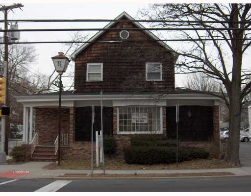
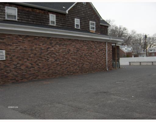
Property Record
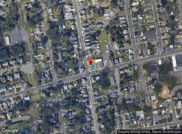
343 Washington Rd, Sayreville, NJ 08872

NEARBY LISTINGS FOR SALE OR LEASE
Property Detail
343 Washington Rd
New York-Jersey City-White Plains, NY-NJ
Intersection Improv
19-00124-0000-00017-03
69X102
Commercialofficeresidentialmixeduse
Middlesex
X
New Jersey
34023C0153F
17.3
2024
0.16 AC
2025
South Edison
007202
Northern New Jersey
DEMOGRAPHICS near 343 Washington Rd
1 Mile
3 Mile
5 Mile
2024 Total Population
12,390
67,044
210,004
2029 Population
12,304
66,621
208,573
Pop Growth 2024-2029
(0.69%)
(0.63%)
(0.68%)
Average Age
42
40
41
2024 Total Households
4,414
24,128
76,551
HH Growth 2024-2029
(0.77%)
(0.72%)
(0.70%)
Median Household Inc
$102,654
$90,536
$95,223
Avg Household Size
2.80
2.70
2.70
2024 Avg HH Vehicles
2.00
2.00
2.00
Median Home Value
$389,274
$376,812
$381,736
Median Year Built
1969
1967
1966
Nearby Places
Map Layers
Map Styles
 Street
 Aerial
- Restaurants
- Banks
- Shops
- Fitness
- Groceries
PUBLIC TRANSPORTATION
COMMUTER RAIL
South Amboy (North Jersey Coast Line - NJ Transit Commuter Rail (NJ Transit))
DRIVE
WALK
Distance
South Amboy (North Jersey Coast Line - NJ Transit Commuter Rail (NJ Transit))
11 min
4.4 mi
Perth Amboy (North Jersey Coast Line - NJ Transit Commuter Rail (NJ Transit))
DRIVE
WALK
Distance
Perth Amboy (North Jersey Coast Line - NJ Transit Commuter Rail (NJ Transit))
13 min
6.8 mi
AIRPORT
Newark Liberty International
DRIVE
WALK
Distance
Newark Liberty International
37 min
27.5 mi
Trenton Mercer
DRIVE
WALK
Distance
Trenton Mercer
53 min
35.0 mi
Freight Ports
New York Container Terminal
DRIVE
WALK
Distance
New York Container Terminal
30 min
19.6 mi
Nearby Properties
Address
Land Use
TOTAL SIZE
Lot Size
Zoning
Address
Land Use
TOTAL SIZE
Lot Size
Zoning
176.53 AC
G1
Address
Land Use
TOTAL SIZE
Lot Size
Zoning
81,600 SF
49.89 AC
LI
Address
Land Use
TOTAL SIZE
Lot Size
Zoning
Address
Land Use
TOTAL SIZE
Lot Size
Zoning
726 SF
75.46 AC
P
Address
Land Use
TOTAL SIZE
Lot Size
Zoning
24.19 AC
R100
Address
Land Use
TOTAL SIZE
Lot Size
Zoning
7,904 SF
60 AC
AF
Address
Land Use
TOTAL SIZE
Lot Size
Zoning
58.78 AC
LI
Address
Land Use
TOTAL SIZE
Lot Size
Zoning
315,200 SF
22.76 AC
LI
Address
Land Use
TOTAL SIZE
Lot Size
Zoning
7.41 AC
MXD
Address
Land Use
TOTAL SIZE
Lot Size
Zoning
52.04 AC
RRRD
Address
Land Use
TOTAL SIZE
Lot Size
Zoning
34.63 AC
LR
Address
Land Use
TOTAL SIZE
Lot Size
Zoning
Address
Land Use
TOTAL SIZE
Lot Size
Zoning
52.80 AC
LI
Address
Land Use
TOTAL SIZE
Lot Size
Zoning
41.20 AC
RRRD
Address
Land Use
TOTAL SIZE
Lot Size
Zoning
89.43 AC
LI
Address
Land Use
TOTAL SIZE
Lot Size
Zoning
329.22 AC
I
Address
Land Use
TOTAL SIZE
Lot Size
Zoning
7,905 SF
26.55 AC
CC
Address
Land Use
TOTAL SIZE
Lot Size
Zoning
169.71 AC
I
Address
Land Use
TOTAL SIZE
Lot Size
Zoning
367,200 SF
34.22 AC
HC2
Address
Land Use
TOTAL SIZE
Lot Size
Zoning
7,904 SF
30 AC
AF
Address
Land Use
TOTAL SIZE
Lot Size
Zoning
7,905 SF
22.82 AC
CC
Address
Land Use
TOTAL SIZE
Lot Size
Zoning
14.34 AC
R100
Address
Land Use
TOTAL SIZE
Lot Size
Zoning
19.97 AC
P
Address
Land Use
TOTAL SIZE
Lot Size
Zoning
7,904 SF
69.62 AC
AF
Address
Land Use
TOTAL SIZE
Lot Size
Zoning
95.75 AC
I
Address
Land Use
TOTAL SIZE
Lot Size
Zoning
775 SF
26.95 AC
RAWDI
Address
Land Use
TOTAL SIZE
Lot Size
Zoning
3,850 SF
22.94 AC
G1
Address
Land Use
TOTAL SIZE
Lot Size
Zoning
47.57 AC
SED
Address
Land Use
TOTAL SIZE
Lot Size
Zoning
18.19 AC
G1
Address
Land Use
TOTAL SIZE
Lot Size
Zoning
33.51 AC
I
The World's #1 Commercial Real Estate Marketplace
Connect with us
© 2025 CoStar Group
The information above has been obtained from sources believed reliable. While we do not doubt its accuracy we have not verified it and make no guarantee, warranty or representation about it. It is your responsibility to independently confirm its accuracy and completeness. Any projections, opinions, assumptions, or estimates used are for example only and do not represent the current or future performance of the property. The value of this transaction to you depends on tax and other factors which should be evaluated by your tax, financial, and legal advisors. You and your advisors should conduct a careful, independent investigation of the property to determine to your satisfaction the suitability of the property for your needs.